Tuesday, November 26, 2013
Project 2 Structures with Voronoi
1. Project Result


Band Metric
Perspective

Detail of Voronoi
2. Project Process
- Input grid attached with graphic

- Crossing Point on the grid

- Using Battery to elevated the points which located on the white part of the graphic
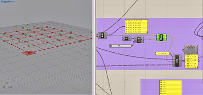

- Connect the points in curves

- Loft the curves

- Using Python select the points which located on the white part of the graphic


- Create domain for random points

- Create bounding box to defined the region according to the random points

- Create Voronoi within the regions

- Extrude the voronoi

- Extrude the lofted surface and cut it with voronoi shape

- Results


Tuesday, November 5, 2013
Thursday, October 31, 2013
Using Rhino and Grasshopper to Locate the Structures Based on the Landscape Condition
1. Project Introduction
The goal of this project is to use Rhino and Grasshopper to locate the crescent dune structures in the tiger bush landscape for land restoration.

2. Background Introduction
All the back ground information below based on the research:
Fragmentation and changes in hydrologic function of
tiger bush landscapes, south-west Niger
The aerial photos show the conditions of tiger bush landscape in 1960 and 1992. The black part is where covered by vegetation bands and the white part is the bared land. In these images we can see the the vegetation band have became more and more fragmented and the site have deteriorated in recent years.
Tiger Bush Landscape

(Wu, Thurow and Whisenant, 2000)
Copyright at British
Ecological Society
Journal of Ecology,
88, 790-800
The photo of tiger bush landscape and symbolized form of land conditions.

(Wu, Thurow and Whisenant, 2000)
This section show how vegetation bands capture the water and keep the land sustainable. Once the structure is broken, the vegetation band will become more and more fragmented and the erosion start. So I want to located the crescent dune structures in the break point and help to capture the water and prevent future erosion.

Zoom in view and analysis done by ecologist for study of the changes of tiger bush landscape.

(Wu, Thurow and Whisenant, 2000)
3. Method
3.1 Symbolized the Site Conditions
First I use this symbolized image to mimic the condition of a tiger bush landscape. The white dots represent the break point of vegetation band and it is the the place to be located the structure.

3.2 Set the relation between the image and grid's cross points
Drag the image into grasshopper and connect it with SqGrid node. The function of the SqGrid is to create a grid and output the cross point information. Double click the images can set the size of how it attached in the rhino. So the grad's cross point and the image have set a corresponding relationship based on the cross point.

Create 3 curves as spine lines for the structure based the sand dune shape in the natural environment. The shape of the structure can be changed base on these 3 curves and the base point of the structure would be the mid point between the start and end point of the curve. This ensure the structure can be well located in the break point on the site.

3.4 Give the model a light green color in the front and a dark green color in the back.

3.5 Use "Kangaroo", "Spring" and "Uforce" to give a physical based surface.

4. Test and Result
As we change the size of the grid, the corresponding information of the cross point changes, this help us to mimic the different condition of the site. We can see that the the arrangement of the structure changed. In reality, we may insert different sit condition images to locate our structures.


5. Thank you!
Subscribe to:
Posts (Atom)